Signpost
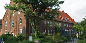
Institute of Medical Informatics
University Münster
Albert-Schweitzer-Campus 1, Building A11
48149 Münster

Institute of Medical Informatics
University Münster
Albert-Schweitzer-Campus 1, Building A11
48149 Münster
By bus from the main train station
From the central station a variety of bus lines leads to us (exit "downtown", bus platform on the forecourt). We recommend the bus lines 11, 12, 13, 22 and 34.
The journey to the stop Domagkstraße takes about 11 - 15 minutes, here you have to get off. Now use the pedestrian crossing and walk about 50m right following the footpath sign until you see a street with a barrier on the left. Follow this road and you will come straight to the entrance of the institute.
By car from the highway
From the north:
Take the Münster-Nord exit on the BAB 1 and drive towards the city center in the direction of the city centre. At the outer ring road, turn right into Orleansring. Before the 2nd intersection (Coesfelder Kreuz) you will see the Coesfelder Kreuz car park on the right-hand side. Directly in front of it, turn right into Wilhelm-Klemm-Straße, then follow Domagkstraße and park in the car park. The walk from the multi-storey car park to the library takes about 10 minutes. Leave the multi-storey car park in the direction of the Ring and follow this across the intersection to the Domagkstraße bus stop. Follow the footpath sign on the right for approx. 50 meters further until you see a road with a barrier on the left. Follow this road and you will come straight to the Institute for Medical Informatics.
From the south:
At the Münster-Süd motorway junction (BAB 1 X 43), drive straight ahead towards the city center on Weseler Straße until the zoo and university clinics are signposted to the left. You follow these signs. In the course you follow the Kolde-Ring over the Aasee, the Kardinal-von-Galen-Ring and the Rishon-Le-Zion-Ring. If you turn left towards the university clinics (Coesfelder Kreuz), turn into Einsteinstraße. Then turn right into Corrensstrasse, at the next opportunity right again into Wilhelm-Klemm-Strasse and right again into Domagkstrasse. The walk from the multi-storey car park to the library takes about 10 minutes. Leave the multi-storey car park in the direction of the Ring and follow this across the intersection to the Domagkstraße bus stop. Follow the footpath sign on the right for approx. 50 meters further until you see a road with a barrier on the left. Follow this road and you will come straight to the Institute for Medical Informatics.
Due to major construction work on the UKM site, you can find the UKM's official directions page here.
| ...FOR YOUR ORIENTATION | ...FOR YOUR INDIVIDUAL CONNECTION |
Location in Google Maps | Timetable information of the Stadtwerke Münster (VGM / VRL) |